Learning Your Own Weather Predicting Skills

Van Living Forum

Help Support Van Living Forum:

This site may earn a commission from merchant affiliate links, including eBay, Amazon, and others.
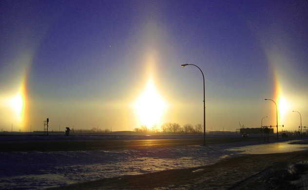
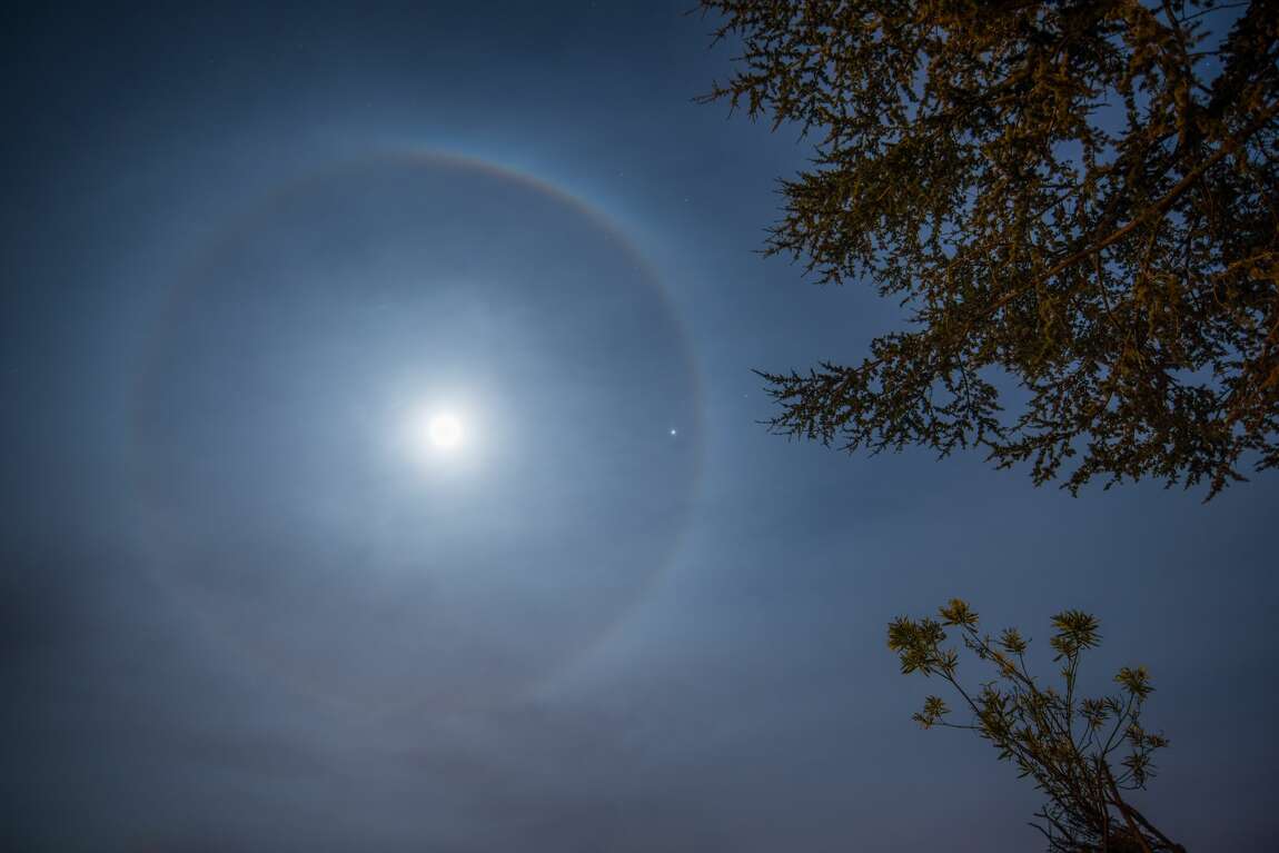
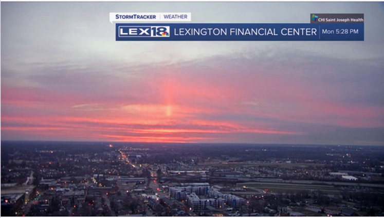
Mother Nature certainly has been a good provider of clues from our environment. The Sky, Land, Water, and Air all contain clues. A couple of the more unique ones from the daylight hours are the "Sun Pillars" and even more rare are the "Sun Dogs" which may appear to either side. At night the Halo Cloud around the Moon.

Sun_Pillar.jpg


Sun_Dogs.jpg


These phenomenon during the daylight hours generally indicate rain is coming.

The halo around the Moon at night indicates a general change in the weather leading to rain.

Some other weather clues are listed here:

17 signs that help forecast weather

Many more signs to look for

Superstitions about the weather that are often accurate

"1001" Hints about predicting weather

Book: "The Secret World of Weather"

1150x0.jpg


Following post will discuss using Weather Instruments & Gauges.
 
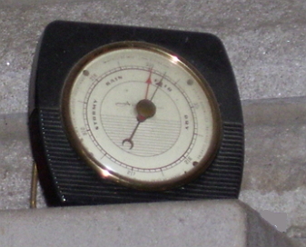
Many Christmas mornings ago, when I was about 10 years old, my father gifted me a Barometer. I think dad thought it would be a good addition to the house too. Like an old friend, it's been with me since. It was made by Airguide which sold out to the Johnson Wax company in 1980 and then closed production in 2000.

Barometer_AG.jpg


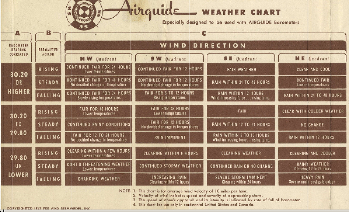
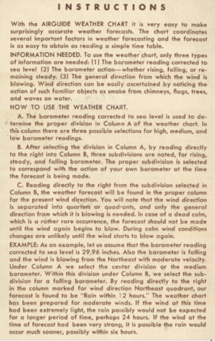
It came with a card board fold out chart that contained information
regarding the readings and wind direction to predict forthcoming weather conditions. It's been quite accurate over the years. The chart is below.

Weather forecasting with the aid of instruments gauges.

If you only have a simple analog Barometer with needle showing inches of mercury and a marking hand to track any movements, you can mark your Barometer to determine whether the Barometric pressure is steady, rising, or falling. Then you can make a fairly accurate forecast if you know the wind direction. Again, you'll be looking to nature for clues of wind speed & direction. But, if you wish to build a simple Weather Vane it is easy to mark North, South, East, and West to determine wind directon. (in the morning the sun rises in the East so if you face east, your left side will face North, your back face West and your right side face South so you can lay out stones to mark these points of the compass. Using a larger stone to represent North and a smaller one to represent East. (Easy enough to figure out the other two directions) This would work if you are in surroundings that are new to you. IF after dark you could look for the "Big Dipper" constellation and measure out five links off the cusp to locate "Polaris" the north star. But it is always nice to have a compass in your rig.

Today you can buy an inexpensive Digital Barometers that also offer a humidity gauge, thermometer, with even a forecasting graphic. This instrument will indicate whether the Barometer is steady, rising, or falling. The Humidity gauge will, if the reading is falling, may indicate a rain front is forthcoming as storms tend to draw moisture out of the air for some fifty or more miles ahead of them. If it is steady or rising it may hint that fair weather may be expected.

It would be easy enough to make a Wind Vane, just place it out in the open with no obstructions around it. With this simple set up you could just about have your own weather station. Clues to wind speed from the environment (using the Beaufort Scale) may indicate how fast the the weather may be changing. You could make a rain gauge from a tall narrow bottle if you wanted or buy one at a Walmart as they are cheap enough.(just remember to empty it if the temperature is falling below freezing as the water in it may turn to ice and break the gauge.

Digital Barometer, Hygrometer, & Thermometer with Weather Graphic

Even if you are listening to a weather forecast on the radio or TV from a nearby city, it may not be as accurate for the place where you are. The Airguide chart will indicate what you could expect within six to forty eight hours of your reading. This chart can be used with your Barometer and knowledge of the wind's direction. You could print it and put it in a cheap frame from Dollar Tree to keep in your rig with your Barometer.

You can click on these two images below and enlarge them. Then drag them about to view the information in them.

Airguide_weather_Chart.jpg


Guide to using the chart

Airguide_Instructions.jpg


Cheap analog Dial Type Weather Station Barometer Measure Barometric Pressure.

Cheap Dial Barometer

Barometer with Hygrometer & Thermometer

Cheap hand held Anemometer to gauge wind speed

If you would prefer to just spend some money and purchase an automated "Weather Station", this type of gauge will provide a color display showing indoor & outdoor conditions along with a weather forecast graphic. It comes with a small unit that needs to be mounted in a safe place outside of your rig. If you have a spare tire mounted on a rear door, it could be mounted under the cover of the tire and be safe from rain, snow, ice, or road spray when traveling.

Automated Weather Station

There are now over 50 reports of people having died in this Christmas 2022 storm. This time of year SAFETY needs to be a primary concern for anyone and especially full time RV people....even if your RV is a built out Van Rig. It's nice to know you have a heating system but should it fail or run out of fuel in a prolonged weather event like this past one would you know to take shelter where you can survive. Your survival may depend on it.
 
Last edited:
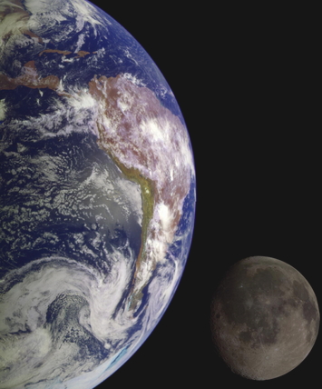
A key component of earth's weather is our only natural satellite, the moon. Yet few today understand how it's influences with it's eight phases and gravitational pull on earth can be a rather accurate aid in forecasting the weather.

earth_moon.jpg


Since I was a kid I wondered why the weather forecast in the newspaper so often gave information about the moon. Why ?
What's the moon got to do with the weather here on earth ?
It's nearly 240, 000 miles away. Yet, it's always there with weather forecast, and little is explained regarding it. It's just "there".
Sure, I had heard in school that the moon influenced our high & low tides at sea but that was about all our teacher could tell us about it.
(but by this time people's reliance on radio & TV weather reports had overtaken the need for personal forecasting skills)

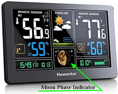
Moon_Phase_Indicator.jpg


See ? (but do you see any explanation of what it would mean to you ?)

Well, we will now examine what you would need to know to make use of this information. During the mid 1700's Sir William Herschel began to research what was known then about the moon and it's suspected influence on the weather. By the later 1800's his son Dr John Herschel carried on his father's work and with his friend (Dr Charles Lyell) help develop what would come to be known as,

"Herschel's Table For Foretelling The Weather"

This relied on the any of the eight phases of the moon as they changed to produce a forecast. Taken into consideration in this is the earth's tilting on it's axis such that the sun heats the alternating hemispheres and the moon's gravitational influence on the oceanographic realm of tides, magnetic forces, and humidity in the air creates movements and changes in the atnosphere . With the sun's heat stirring the warm air into cooler air it will produce weather conditions. Herschel calculated that knowing the time of the changes of the phases of the moon could aid in forecasting up coming weather events. This works with impressive accuracy. (probably why we still see the "moon" mentioned in weather forecasting) Yet the weather people on radio & TV rarely discuss this today.

There are eight phases of the moon. The 29.5 day cycle starts with the new moon, then the waxing crescent, first quarter, waxing gibbous, full Moon, waning gibbous, third quarter and waning crescent. The prediction of the changing of the moon's phases can still be found in an Almanack, on Calendars, or online today. (see the links below)

This table and the accompanying remarks, originally formed by Dr. Herschel, and approved, with some alterations, by the experienced Dr. Adam Clarke, are the remarks of many years' close observation, the whole being on a due consideration of the sun and moon in their several positions respecting the earth. They claim to show what kind of weather will most probably follow the entrance of the moon into any of its quarters. If the new moon, first quarter, full moon or last quarter happens -

Between.In Summer.In Winter.
12 and 2, morn.Fair....................Hard frost, unless wind be S. or E.
2 and 4, " .Cold, frequent showers...Snow and stormy .................
4 and 6, " .Rain ..................Rain ...........................
6 and 8, " .Wind and rain ..........Stormy ........................
8 and 10, " .Changeable .............Cold rain if w. be W.; snow if E ....
10 and 12, " .Frequent showers .......Cold and high wind ...............
12 and 2, aft'n.Very rainy ...........Snow or rain ....................
2 and 4, " .Changeable ...........Fair and mild ....................
4 and 6, " .Fair ..................Fair ...........................
6 and 8, " .Fr. weath. if w. N. W.;. (rainy if w. S. or S. E..,. Fr. and frosty if w. N. or N. W.; rain or snow if S. or S. E..
8 and 10, " .
10 and midnight.Fair ..................Fair and frosty ...................
1. The nearer the time of the moon's change, first quarter, full or last quarter are to midnight, the fairer will the weather be during the seven days following.

2. The space for this calculation occupies from 10 at night till 2 next morning.

3. The nearer to midday, or noon, the phases of the moon happen, the more foul or wet weather may be expected during the next seven days.

4. The space of this calculation occupies from 10 o'clock in the morning to 2 in the afternoon

This bears out with this past Christmas Blizzard/Storm on 12/23/22.

Huntington, WV is the closest large town near me and this moon phase chart for December 23, 2022 indicates the time of change is 5:17 am for the "new moon". The storm was hitting this area about 4 hours earlier but there were very high winds and higher gust during this time perhaps bringing the storm on a bit earlier. (-44 degrees wind chill) The bottom link below suggest...."The days following a new Moon or a full Moon are typically stormy"

If you look at these two charts linked below you can see how close the storm correlated to Herschel's table.

December 2022 moon phase time of change

Weather for you archive record of 12/23/20

Here are 10 tips about using the moon to predict weather

Weather Folk Lore and using the moon

Could we have seen this coming if we didn't have Radio, TV, or the Net ? Using Herschel's methods ? If we did, would we have chosen not to travel and risk being stranded ?
 
Last edited:
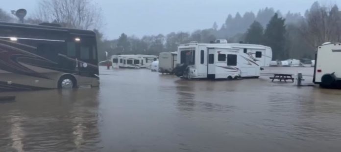
Many people form their view of the weather based on their childhood experiences. They may believe that weather is something that only comes from the sky to the earth. In truth, much of it does but much more of the origin of weather is related to the oceans where the Sun's heat and Moon's gravitational pull intermingles the oceans moisture with the atmosphere while creating winds, clouds, rain, snow, and often these days.........flooding.

2021-11-12_11-36-39-696x311.jpg


Many Nomads seek the comfort of the southern coastal regions during the winter months or campsites in cool woodland areas by a stream in warm weather. But adverse weather. even if it occurred miles upstream, may compromise the security of their campsite with unexpected flooding. Who would want to be startled in the night by hearing flood water splashing up against their rig ?

Our National Weather Service is known as NOAA (National Oceanic and Atmospheric Association) The title pays tribute to the importance of the oceans role in our weather.

Again, the Sun and Moon have great influence over the Oceans. The gravitational pull of the Moon may even have bearing on earthquakes & tremors. As the Earth & Moon have elliptical (foot ball shaped) orbits around the Sun, their various positions thru the month create constant changes in our weather patterns. Learning to follow these extraterrestrial changes is easy today as it has been recorded over the centuries and is readily available for our reference in Almanac's, and on certain Calendars.

The link below offers an animated view of the Sun, Earth, and Moon from space and displays the influence they exert on the Oceans.

NOAA explanation of Sun Moon and Tides & Water Levels

The link below looks at the Earth's Ocean currents from Space and provides a podcast to explain the map of the Atlantic & Gulf Stream. It also addresses the weather conditions these currents may influence.

NOAA podcast and how Ocean Currents Influence our Weather

This Youtube video (2 minutes) explains weather related sea level rise

Rising Tides: Understanding Sea Level Rise

Friday January 6 at 4:38 am est the Moon's phase will shift to the last quarter. We know that there is a big storm moving across the USA now. High winds, heavy snow, in the central part of the USA and heavy rains in the south are taking place now. 1/3/2023

If we referred to Herschel's Chart:

It claims to show what kind of weather will most probably follow the entrance of the moon into any of its quarters. If the new moon, first quarter, full moon or last quarter happens -

Between.In Summer.In Winter.
12 and 2, morn.Fair....................Hard frost, unless wind be S. or E.
2 and 4, " .Cold, frequent showers...Snow and stormy .................
4 and 6, " .Rain ..................Rain ...........................
6 and 8, " .Wind and rain ..........Stormy ........................

In southern Ohio, a cooler rainy weather trend appear to correlate with Herschel's chart by Friday. 1/6/2023
 
Understanding the weather clues nature provides for us should translate into our preparedness. Our rigs may be frail when compared to the sticks and bricks homes we may have been accustomed to when young. It's unwise to believe our rig would be just as safe. So if we are living on the road in a rig we must be more alert and responsible to ourselves by being prepared for adversity. Using our good common sense should be a constant practice.

The Boy Scouts have long been known for two things: their outdoor activities and their motto, "BE PREPARED". Nomads could benefit by adopting that motto too.

This site offers the story of a RV'er with two years of experience on the road. He has written a good checklist to assure preparedness.
(anyone can replicate it)

Storm Preparation Story for RV'ers

My own "close call" weather story didn't take place in my rig. (thank heavens) I was driving out to Loveland, Colorado (north of Denver) and had left St. Louis, MO around 9:30 pm in a Honda I owned back then.

Around 2 am I was entering into the Kansas City area and pulled into a gas station to fill the tank. A fellow who had just fueled his Pickup Truck Camper approached me and said he noticed my Ohio plates and wanted to warn me about a big storm he had been running ahead of while trying to get back to his home east of KC. He suggested I pull over across the road in this graveled parking lot that had a west facing wall that I should park beside. I did this as the wind was really picking up by that time. Within minutes debris was flying thru the air followed by torrents of heavy rain. I looked down at the ground and saw lots of water running by and I began to really worry. Lightning was flashing and thunder pounding a minute later. Across the lot was a parked delivery truck vigorously rocking back and forth in the heavy wind. I was really appreciating his advice by this time. Wondering if a tornado was close by.

After about twenty minutes the heavy rain eased but the wind was still gusting with rain. Later I hit the road and drove on towards my destination but by daylight I began seeing Tractor Trailer rigs blown over on their sides beside the Interstate. Saw lots more of them as I continued on. Had I been in my rig without the benefit of his warning, I could have been blown over on my side too.

Fortunately Ohio is a State that uses a front facing license plate and the guy saw it and realized I was from "back east". He realized I wouldn't be familiar with weather on the plains....and possibly driving into a tornado at night. It cost him a few precious seconds of his time and I'll always be grateful to him for it. (hope he made it home OK) I'd brought a CB radio but it and the car's radio were turned off. I was much younger then and not so wise. Only focusing on making time and putting miles behind me while unaware of the weather forecast or being in any way prepared, I was oblivious to my own safety. And very lucky too.

I learned from that.
 
Friday January 6, 2023 the Moon's Phase will shift to "full Moon" at 6:08 pm est. Worth watching the present weather reports as current weather events on the west coast are making big news now. You may be hearing about the "Pineapple Express" making landfall in California at this time and not understand what it all means.

So what is a Pineapple Express ? It is an Atmospheric River that carries huge amounts of moisture. It's 4000 miles long and gets it's name as it originates from the tropics near Hawaii (once a primary source of Pineapple farming) and is rated on a 1 to 5 scale. (similar to the way Hurricanes are rated on the Sanford Simpson Scale) It could be a rough and dangerous time for a Nomad to be caught in just a level #2 event as it likely to cause lots of flooding.

Weather reports indicate that this present storm may be the first of three events. This one alone is pulling the west out of the drought it has been in for the last three years. San Francisco alone has recorded 10 inches of rain fall so far.

Here is a chart that explains the USGS rating system below:

Atmospheric River rating system chart

NOAA explanation of this phenomenon

AgDay, a half hour national agriculture news report, is giving lots of coverage to this today. 1/6/2023 Commercial Farmers rely on the coverage and quality of their weather reports If you are on the west coast, today's program may be well worth your watching.

AgDay Site.

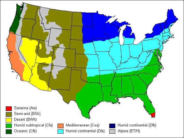
Climate Zones of the USA

When traveling great distances in the USA, as many Nomads do, it may be worth being aware of the various climates of the country. Each will have it's own weather patterns due to physical features of the land. Mountains, plains, large bodies of water (great lakes), degrees of latitude, and unique coastal conditions. All of this will have bearing on your personal safety, comfort, and convenience to enjoy your travels.

USA_Climate_Map.gif
 
As January's winter weather, rain & snow, is setting in from the west coast now, some terms such as "cloudy" or "overcast" are slung around loosely. There is actually a method for accurately reporting cloud coverage known as the "Oktas Scale". This cloud cover can greatly influence the weather.

Dense cloud coverage is a weather variable that hasn't been discussed and yet it may have a major influence on our lives.
Gauging the sky coverage with clouds will give clues to how cold the atmosphere may become at night. In sandy soil areas, that have high cloud coverage at night, the heat absorbed by the ground in the day time may be held in thru the night. Many full timers are attracted to coastal areas where it is sandy. If there is no dense cloud coverage that night the heat may quickly radiate into the night sky. (just one example) This may also influence land or sea breezes or the mountain or valley breezes. And this have direct bearing on your comfort depending on where ever your RV is camped.

In the daylight hours cloud coverage may dim the light and even limit the efficiency of solar panel arrays. If rain or snow comes from the clouds it may further limit one's comfort and or ability to travel.

The Oktas Scale is divided into 8 sections. (imagine a pie graph) a few clouds in the sky may be 1 Oktas. But a completely covered sky with perhaps a few small holes...may be 8 Okats on the scale.

Much of our weather conditions come from the Sun's energy shining on the land or sea. A blanket of clouds, which may be of various thicknesses, can adjust the weather we encounter on it's own. If we are full timing, living in off grid areas, or snow birding around the coast or sandy soil areas, this aspect of weather is something to keep an eye on.

This site explains the Oktas Scale and many other weather conditions.

Oktas Scale explanations

What the "Old Farmer's Almanac" is forecasting for the winter of 2023.

2023 Winter Forecast
 
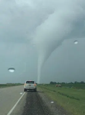
So, by developing a more personal understanding of weather signals to be ready for whatever comes, a Nomad can have time to prepare or take "safer" shelter. Whether he or she is traveling or in camp there are some different steps to take in order to be safe. Any traveler or camper should consider how they could quickly get to safety should need arise. Tornado season isn't far away.

TORNADO-NWS.jpg


"The Travel" site looks at 8 major weather perils and offers suggestions that are worth considering if confronted by them :

How to stay safe during bad weather while traveling

"RV Travel" has numerous testimonials by those who have experienced severe weather events that are worth reading.

Have you ever been stuck in your RV during a storm so violent you feared for your safety?
 
Last edited:
In the overview of weather patterns of the USA as it relates to Nomads, the typography of the lower 48 states is a remaining topic that hasn't been addressed as much. There are two major mountain ranges known as the Rockies and the Appalachians that do much in shaping where and how much precipitation will occur.

Western mountain ranges actually block moisture from reaching the areas between the Rockies and the Mississippi River basin. (between the 100th & 98th meridian on the map) These areas are where much of the BLM lands exist and numerous Nomads choose to live.

BLM Recreation Map/Camping

The climate of the states west of the Rockies has plenty of moisture from the Pacific Ocean blown in to that region, but there are mountain ranges in that area that shape, and direct moisture flow within it's region. But by the time the moisture reaches the Rockies much of it is blocked and doesn't get past there to the central plains west of the 100th meridian just west of the Mississippi River basin.

This Youtube video helps to explain the phenomenon (nearly 20 minutes with an advertisement at the end) This may be of value to traveling Nomads or BLM campers.
It offers an explanation as to why 80% of Americans live east of the Mississippi River and shows the areas where most of the rest of the worlds population live. It is quite informative to see how mountain ranges shape our weather climate and where we most likely choose to live or may have to avoid living in order to be safe and comfortable.

Where 80% of people live in the USA
 
Top