My map of all travels

Van Living Forum

Help Support Van Living Forum:

This site may earn a commission from merchant affiliate links, including eBay, Amazon, and others.

Van-Tramp

Well-known member
Joined
May 5, 2013
Messages
1,734
Reaction score
6
Location
Planet Earth
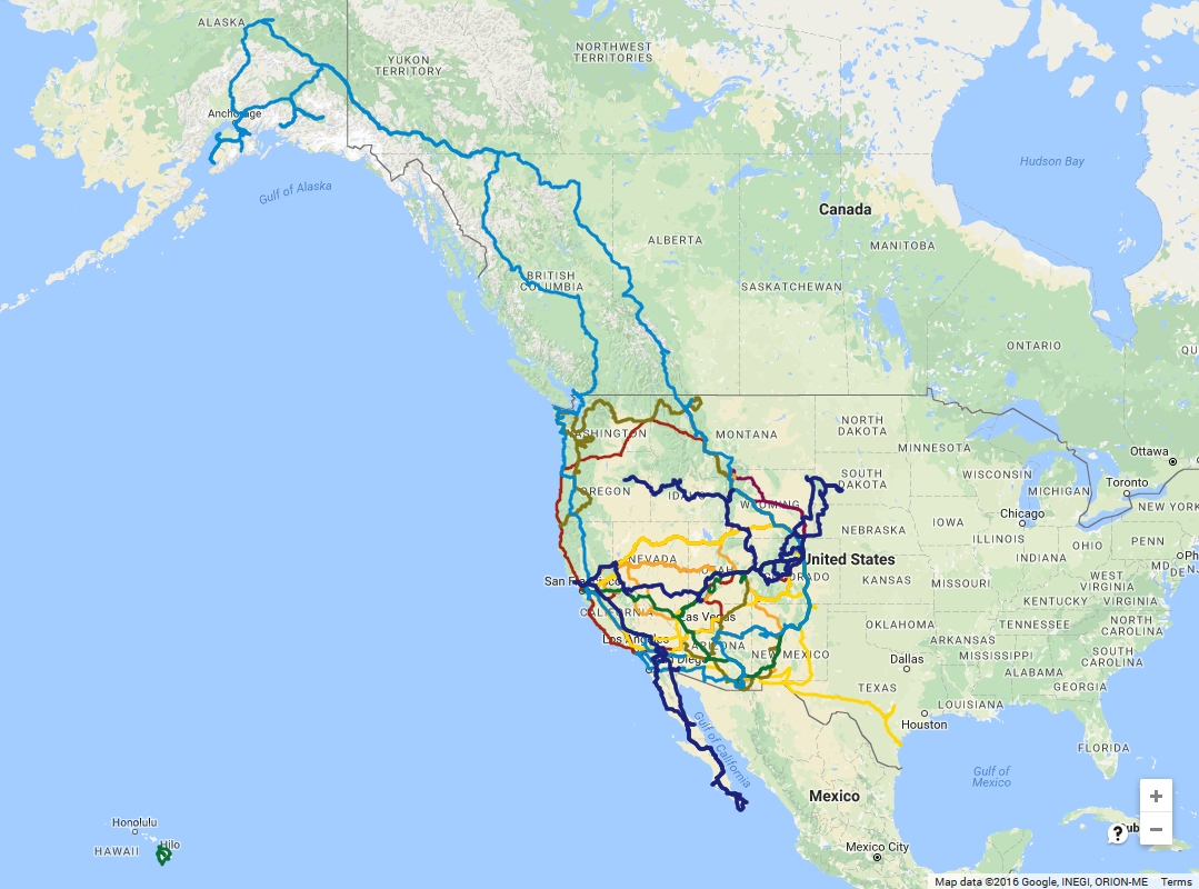
I spent some time today and merged the maps for each of my individual years of traveling, since 2009. Took some serious effort since Google Maps has so many limitations on how many points and layers you can have on a single map, but here it is... color coded by year.

Roughly 70,000 miles, 75+ National Parks, 16 American states, 5 foreign states, and 3 countries of exploring since I started this lifestyle 7 years ago.

and if you really want to explore it, check in out on Google Maps


vt_alltimetravelmap.jpg
 
That's cool! Google can be such a pain in the ass for this kind of thing, so I can appreciate the work it must've taken
 
And actually - could you share how you made this? (I assumed from your post that you combined a bunch of different screen captures into one picture, but then I saw the link.)
 
Excellent, love the Western bent!

Haven't done AK yet,but other than that, the looping of the western states is ideal. I enjoy eastern parks, but nothing touches the emptiness and grandeur of the West.
 
Very nice! I hope to get out there as much some day.

For those of you looking to make routes with actual Google maps, share routes, export them to various GPS devices, and have as long of a "route" (your year's travels if ya like) as you feel like.... check out http://www.routeyou.com  I use it for planning MINI Cooper rallies all over the place.   (sorry for the side step OP)
 
Great map, but there's a big empty space on it. Swing on by the East sometime, it's not as bad as everyone makes it out to be. ;) Especially up here in the Appalachians.
 
East? A little bit on the schedule. In 2017 we will be heading back to Texas, then to New Orleans, Atlanta/Florida, then up to the Great Lakes and across to the PNW again. We are specifically not going to the North East... no thanks. 2018 we plan to stay solely in the Western states (CA, OR, WA) as we will be sail boat shopping.
 
FALCON said:
And actually - could you share how you made this?  (I assumed from your post that you combined a bunch of different screen captures into one picture, but then I saw the link.)

I have had all my yearly maps in Google already, just drawing lines as I go along my travels. But, Google only allows 10-layers so combining them took some effort; Exporting each map out to KMZ format, then loading that into Google Earth to export out as KML format. In KML I can open that file and manually edit them all together and remove the layers, save, and re-import back into Google Maps. Then in google maps I assigned a different color to each year's track and here we are. I didn't know any of this before I started the process, so two days of work was wasted when I ran into Google Maps limitations before finding the solution online.
 
PS - I'd like to mention that all of this traveling was done on my $1000 per month budget in a late 80's van, well until 2015 anyway. Then I started traveling with a partner and who knows how much we spend together in the larger rig.
 
Great blog. Any chance part of your baja budget included shrimp tacos at el Viejo in los Barriles?
 
o3dave said:
Great blog. Any chance part of your baja budget included shrimp tacos at el Viejo in los Barriles?

In fact, yes! We ate there as a group on one of the days we walked into town while camped on the beach nearby,
 
Top