In response to Mountain Directory e-Book to Find Steep Hills

Van Living Forum

Help Support Van Living Forum:

This site may earn a commission from merchant affiliate links, including eBay, Amazon, and others.

SoulRaven

Well-known member
Joined
Aug 7, 2011
Messages
6,759
Reaction score
9
In response to Mountain Directory e-Book to Find Steep Hills [edited by mod to provide link]

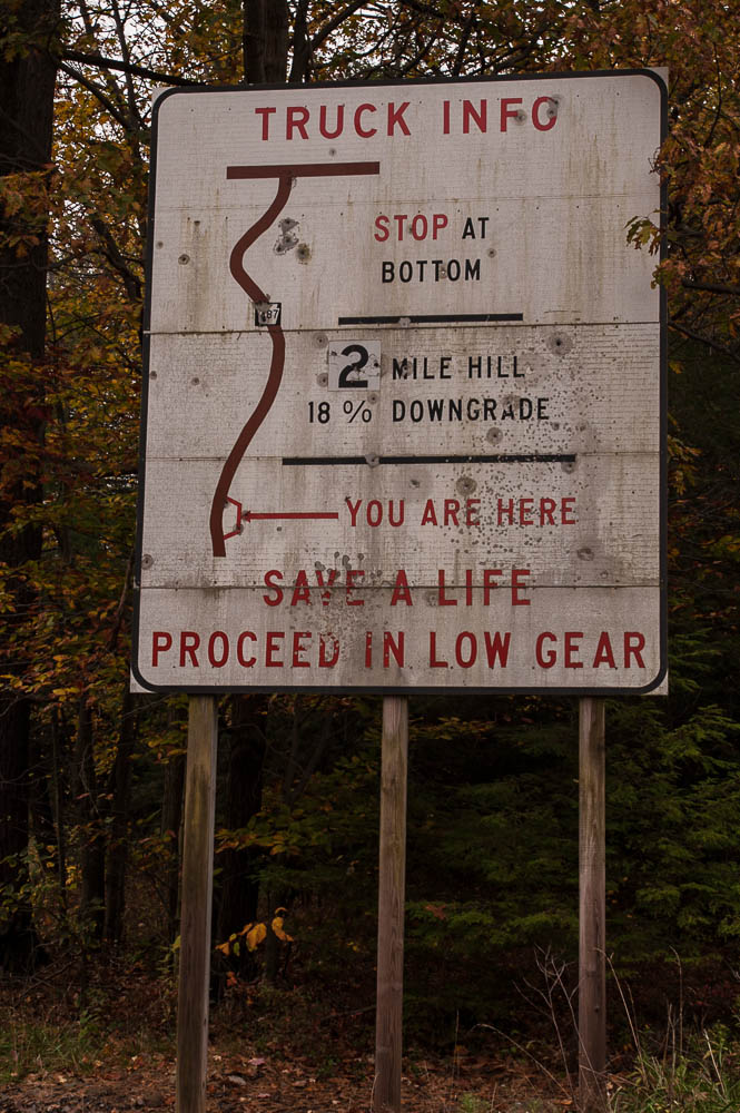
Sign near Ricketts Glen State Park PA RT 487 south elevation 2449'.

ASG_7318.jpg


http://www.dcnr.state.pa.us/stateparks/findapark/rickettsglen/

dcnr_003163.jpg
 
Holy smokes what a steep road... smoking meaning your brakes.

Wonder how far it is to drive back where you came from and take a different road? LOL


And thank you Mr.LooRead for the post. :cool:
 
WriterMs said:
Wonder how far it is to drive back where you came from and take a different road? LOL

I have an appointment to see MY chiropractor next week and it's 51 miles one way down and back up the 18% grade or 57 miles one way to take the alternate route.

The Commonwealth of Pennsylvania pays 100% of the cost of a mini van and a driver thru MATP (medical assistance transportation program).
 
geez 18%, holy smokes, better use low gear. that's almost a foot every 20 feet. I would hate to be on that road in icy conditions. highdesertranger
 
highdesertranger said:
geez 18%,  holy smokes,  better use low gear.  that's almost a foot every 20 feet.  I would hate to be on that road in icy conditions.  highdesertranger

I calculate you wouldn't have to hate being on it for very long!
 
When I was young, we used to spend summers at my Grandmother's house in Altoona, PA.  There was a city street near her house that was nearly as steep as that.  There were houses lining both sides of it.  Makes you wonder what people in PA were thinking.

Regards
John
 
Optimistic Paranoid said:
When I was young, we used to spend summers at my Grandmother's house in Altoona, PA.  There was a city street near her house that was nearly as steep as that.  There were houses lining both sides of it.  Makes you wonder what people in PA were thinking.

Regards
John

They were thinking "Hills, everywhere hills. Well, start building at bottom and stack 'em up the hill. We have to live somewhere."

Pittsburgh has at least one street that I have been on with a very steep grade.

-Wayne
 
I have been to Ricketts Glen SP. .Defiantly worth the treacherous drive. Beautiful water falls hike down thru the valley.

Quote from #6 " There was a city street near her house that was nearly as steep as that. There were houses lining both sides of it. Makes you wonder what people in PA were thinking".

There is no getting away from the mountains in west and north central PA. All of the towns were built near the streams and rivers which would support the industries. Due to the lack of transportation, people would build as close to the jobs as possible which just happen to be the on the steep hills leading out of the valleys. There are some of the older areas where you could almost jump off your front porch and land on the roof of your neighbors.
 
Old Priest Grade near Groveland Ca is about the same. There is a bypass for it, (called Priest Grade), but if you are following GPS instructions you can get into trouble. The elevation changes 1540 feet in 2.7 miles. I have been up and down it many times. The bypass is a lot of fun on a motorcycle, (lots of turns). Going East, (uphill), one has to turn off of the main road to get on the old grade. Going West, (downhill), if you do not turn when the main road does, but go straight instead, You better have a good tranny and breaks.

This is from Wikipedia: https://en.wikipedia.org/wiki/Moccasin,_Tuolumne_County,_California

Priest Grade and Old Priest Grade

Immediately east of town, State Route 120 climbs from about 910 feet (280 m) AMSL elevation to about 2,450 feet (750 m) at Priest Station, California, over a distance of six miles (10 km). Old Priest Grade, a narrower road and predecessor to the current route of SR120, covers the same change in elevation over about 2.7 miles (4.3 km). It is common to see vehicles with smoking brakes descending the old grade. During summer, ambient temperatures can be in the 90~100 °F range. In these temperatures, many vehicles overheat climbing the old grade. Locals tell stories of car accidents in history where the vehicles left the path of Old Priest Grade and tumbled into Grizzly Gulch. The hillsides are sturdy chaparral with thick vegetation. The terrain was so difficult that, in a few cases, the cars and bodies were not retrieved, some locals claim.[citation needed] Construction to widen curves and add guard rails began in July 2010.[5]
 
Top