Hurricane Matthew. East coast possibility

Van Living Forum

Help Support Van Living Forum:

This site may earn a commission from merchant affiliate links, including eBay, Amazon, and others.

SternWake

Well-known member
Joined
Nov 30, 2013
Messages
3,874
Reaction score
2
Not sure how someone with internet connectivity could still be unaware of this possible threat, But

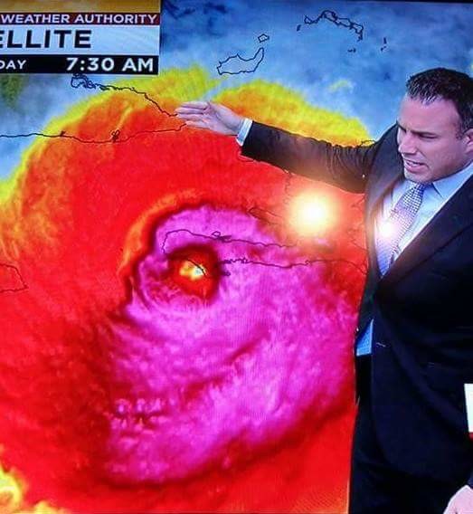
This storm has defied all predictions gong from tropical storm to Cat5 in near record time, and they flat out are saying now they are pretty much clueless as to where this storm is going.

Looks to be over the Bahamas on Thursday as a Cat 3 hurricane after smearing parts of Jamaica, Haiti and Cuba.  The 'cone of uncertainty' is now touching EasternMost Florida, and one of the more reliable weather models ( GFS) has it taking a left turn into the Carolinas.  

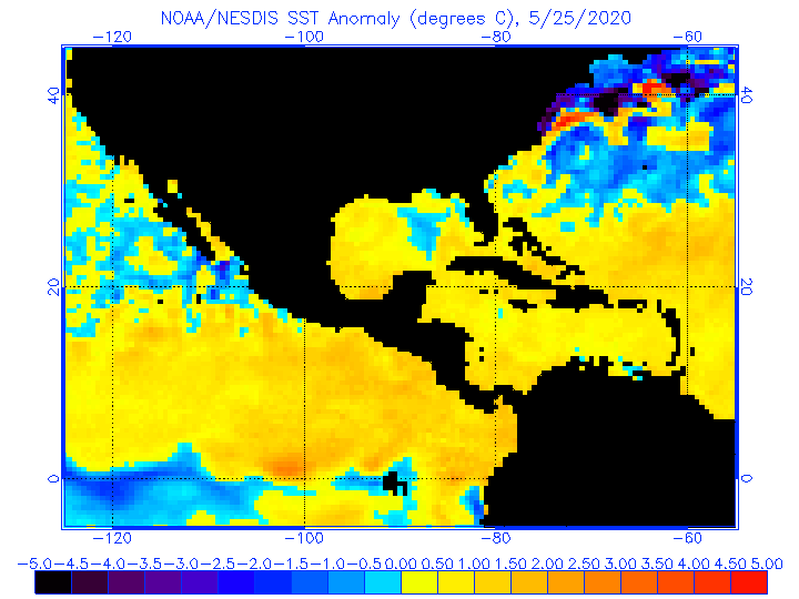
There is tremendous oceanic heat content around the Bahamas with warmer than normal waters extending deeper below the surface, so the Cat3 forecast could be conservative. Also the gulf stream is Hurricane turbo juice and right there too. A couple models have it stalling just over the bahamas too.

If it impacts as a high end cat 3 or low end cat 4 anywhere, it will be fairly devastating.

at201614_5day.gif


Anyway, Keep this storm mind if you live anywhere along The East coast and might possibly put yourself out of information range.

 It is possible it will strafe the whole coastline.  Do not concentrate on where the exact center is is forecast to travel.  The tropical storm force wind field radius, could be immense and coastal flooding might happen well away from coastlines.

Back in 2012, I thought the forecasters were underestimating Sandy's storm surge by not taking into account the tremendous wind field generating a huge long period groundswell on top of which  the locally generated wind swell rode on top of, to really pile up huge amounts of water along the coasts.

I've heard some first hand accounts of water rising 8 feet in 30 seconds in NJ on that storm, from surfers well acquainted with the power of the ocean, who later claimed PTSD from it.
 
Next weekend, the GFS weather model is now claiming the center will be right on top of the OBX Saturday at 4pm.

Then on top of Cape cod at 11Pm Sunday the 9th.

https://www.windyty.com/?2016-10-10-03,24.164,-71.008,4

On bottom right click GFS next to the ECMWF to get the 8 day forecast.

The ECMWF model was the first one to predict Sandy's left turn into NJ in 2012.

The NHC is basically splitting the difference of these two models for their official forecast.

Will be interesting to see how inaccurate the models wind up being. Hopefully the center stays well offshore.
 
Yeah, surfer's pray a little too hard for Hurricanes. I'm sure Sandy changed that for many. Now they get a twinge of fear, and Matthew is basically forecast to follow a similar path as Sandy from the same starting point, but hopefully without the sharp left turn.

October was my favorite month to be a Surfer on the east coast.
 
Latest forecast update at 11Pm eastern has the center almost threading the needle between Haiti and Cuba. The ~ 6000 foot elevations on those islands should not disrupt the storm as much, and now they say it will maintain CAT 3 strength on its way to Bahamas and points north.

If the models are not smoking crack, Matthew could be a historical beast feeding on abnormally warm ocean temperatures in its path.

anomwnc.gif
 
I just heard about this for the first time about two hours ago. But I don't watch the news or listen to weather. The weather is what it is when I wake up every morning.
 
Being a lifelong Floridian I keep a "weathereye" for these tropical storms. We in Tally got fairly lucky with Hurricane Hermine.
This one looks like it won't affect us in my AO. All models published so far have it going up the Atlantic coast. Probably mess up The Carolinas again.
 
Longer-range track forecast for Matthew: risk increases to U.S. East Coast
Over the past two days, our two best computer models have been trending towards a more westerly track for Matthew late this week, increasing the odds that Matthew will make a direct hit somewhere along the U.S. East Coast. Sunday’s 00Z European model and 06Z GFS model had Matthew coming very close to or making landfall in North Carolina 6 - 7 days from now. As one can see from the latest set of ensemble model runs (Figure 4), just about any location along the East Coast could potentially see a hurricane landfall this week. Since the hurricane is expected to be moving roughly parallel to the coast, a long stretch of the coast may receive strong winds and heavy rain from Matthew. We do have three decent models predicting a path for Matthew well away for the U.S. coast late in the week, though—the HWRF, Canadian and GFDL—so it is not yet a foregone conclusion that Matthew will impact the U.S. coast.

source:
https://www.wunderground.com/blog/JeffMasters/comment.html?entrynum=3457

The above quote can be summed up thusly:
They have no idea where when or how strong it will be.

The Windyty GFS model is showing a Giant storm a week out, with a huge wind field. Tropical storm force winds extending hundreds of miles from center. If this were to occur and stay far enough offshore, the surf would be epic. If it occurs and stays close to shore the coastal flooding and beach erosion will set new records. There is also a region of NE winds to be forcast well out to sea, well ahead of the storm. If this were to occur, even without the hurricane, there would be a good groundswell impacting parts of the coast. If the Hurricane takes this swell and adds its energy to it, the coastal flooding and beach erosion potential will be increased.

The Outerbanks could very well be cut off for a significant period of time. The back bays off the chesapeake and most places in the Northeast could see lots of flooding since it appears the storm is a slow mover and will have several high tide cycles to pile the water in and not let it back out.
 
The official NHC forecast track just moved the cone of uncertainty much closer to the SE coastlines, and holds the hurricane at cat 3 strength just a hundred miles off the Florida coastline.

204647W5_NL_sm.gif


Both EWMCF and GFS models have center of storm approaching closer to coastline than official forecast does

If this forecast holds, there could be evacuations disgusting traffic jams. CRVL members in eastern Florida, Georgia and the Carolinas might want to beat the possible traffic and skedaddle earlier.
 
That's why we live on wheels,,,,,,if it looks like it may get bad .... RUN AWAY , RUN AWAY !
Don't even have to pack !
Remember to leave early or be ready to get in a long slow line....................
 
Latest NHC update at 11PM eastern moved cone of uncertainty another 30 or so miles west, toward florida.

Florida and North Carolina already have declared states of emergency.

Direct hurricane impacts are possible in Florida later this
week. Tropical storm and/or hurricane watches are likely tomorrow
morning for portions of the Florida peninsula and the Florida Keys.

3. Tropical storm or hurricane conditions could affect portions of
Georgia, South Carolina, and North Carolina later this week or this
weekend, even if the center of Matthew remains offshore. It is too
soon to specify what, if any, direct impacts Matthew might have on
the remainder of the U.S. east coast farther north. At a minimum,
very dangerous beach and boating conditions are likely along much of
the U.S. east coast later this week and weekend.
 
Looks like a near worst case scenario for Florida.

034341W5_NL_sm.gif


The images coming out of Haiti and Cuba show rather massive destruction

This is apparently not photoshopped:
Hurricane-matthew-formed-into-a-skull.jpg


and from when Matthew's eye was just beginning to cross the lower Haitian peninsula.

It is now smearing some Bahaminan islands and reintenisfying and and growing in size.

Some models from more than 5 days out have the storm recurving around and hitting Florida again in a much weakened state.

This storm has the potential to be truly disastrous to a wide swath of Florida's east coast, it already has been to parts of Haiti and cuba, and likely as I type, the Bahamas.

My sister is just outside Orlando and says the gas stations and supermarkets are mob scenes with people already behaving poorly.

Here's hoping it decides to track further offshore than the current forecast has it going.
 
rvpopeye said:
That's why we live on wheels,,,,,,if it looks like it may get bad .... RUN AWAY , RUN AWAY !
Don't even have to pack !
Remember to leave early or be ready to get in a long slow line....................
Brave Sir rvpopeye ran away.
When danger reared its ugly head,
He bravely turned his tail and fled.
Yes brave Sir rvpopeye turned about,
And gallantly he chickened out.
Bravely taking to his feet,
He beat a very brave retreat.
Bravest of the brave, Sir rvpopeye!

Sorry...couldn't resist! Lol.
 
The storm will be the worse toward the central northern coast of Florida. Kind of like Sandy did to South Jersey. My family are hunkered down in Ft Lauderdale, expecting to lose power for a while. I think Orlando will be far enough from the coast to be reasonably safe. Wishing the best for all.
 
Bloody hell! Our condo (that sits about 100' from the intracoastal) is in New Smyrna Beach about 15 miles south of Daytona. It's for sale and it is our entire nest egg. *sigh*
 
Well,I've heard of people seeing Jesus and Mary in a piece of toast,but it's scary seeing my first ex wife's face in a hurricane.
 
My daughter lives on Exuma Island in the Bahamas. Matthew was nearly a direct hit on them. The worst was last night around midnight; 120 mph winds; severe flooding in the main city Georgetown; power out; no cell service; roads blocked with downed trees. No loss of life and only slight structural damage. Nassau is in the midst of it right now.
 
Yikes! Glad your daughter is okay.
 
Bob Dickerson said:
Well,I've heard of people seeing Jesus and Mary in a piece of toast,but it's scary seeing my first ex wife's face in a hurricane.

YOu were married to my Mother in law? Small world huh. ;)
 
We were around Pawley's Island, having a very good time. But we headed west days ago, when the leaving was easy, when Matthew was just beginning to get a lot of attention. Glad we did. Been thru one chaotic last minute evacuation. Didn't feel like doing that again. We are comfortably set up well out of Matthew's way and well out of the way of the last minute evacuees. That's one of the beauties of being retired on wheels.
 

Latest posts

Top